Top Navigation Bar

@*土石流及大規模崩塌防災資訊網logo圖片*@ Debris Flow and Large-Scale Landslide Disaster Prevention Information Network logo image @*土石流及大規模崩塌防災資訊網名稱圖片*@ Debris Flow and Large-Scale Landslide Disaster Prevention Information Network name image
Debris Flow and Large-Scale Landslide Disaster Prevention Information Network

應變開設專區

0814豪雨土石流及大規模崩塌災害緊急應變小組 級開設 未來48小時紅黃警戒推估

警戒統計資訊

紅色警戒

  • 0
    土石流潛勢溪流
  • 0
    縣市
  • 0
    鄉鎮
  • 0
    村里
  • 0
    大規模崩塌潛勢區
  • 0
    縣市
  • 0
    鄉鎮
  • 0
    村里

黃色警戒

  • 0
    土石流潛勢溪流
  • 0
    縣市
  • 0
    鄉鎮
  • 0
    村里
  • 0
    大規模崩塌潛勢區
  • 0
    縣市
  • 0
    鄉鎮
  • 0
    村里

警戒地圖與縣市列表

桃園市
土石流警戒 0 0
大規模崩塌警戒 0 0
目前無發布任何警戒
新竹縣
土石流警戒 0 0
大規模崩塌警戒 0 0
目前無發布任何警戒
苗栗市
土石流警戒 0 0
大規模崩塌警戒 0 0
目前無發布任何警戒
臺中市
土石流警戒 0 0
大規模崩塌警戒 0 0
目前無發布任何警戒
彰化縣
土石流警戒 0 0
大規模崩塌警戒 0 0
目前無發布任何警戒
雲林縣
土石流警戒 0 0
大規模崩塌警戒 0 0
目前無發布任何警戒
嘉義縣
土石流警戒 0 0
大規模崩塌警戒 0 0
目前無發布任何警戒
臺南市
土石流警戒 0 0
大規模崩塌警戒 0 0
目前無發布任何警戒
新北市
土石流警戒 0 0
大規模崩塌警戒 0 0
目前無發布任何警戒
高雄市
土石流警戒 0 0
大規模崩塌警戒 0 0
目前無發布任何警戒
臺北市
土石流警戒 0 0
大規模崩塌警戒 0 0
目前無發布任何警戒
基隆市
土石流警戒 0 0
大規模崩塌警戒 0 0
目前無發布任何警戒
宜蘭縣
土石流警戒 0 0
大規模崩塌警戒 0 0
目前無發布任何警戒
南投縣
土石流警戒 0 0
大規模崩塌警戒 0 0
目前無發布任何警戒
花蓮縣
土石流警戒 0 0
大規模崩塌警戒 0 0
目前無發布任何警戒
臺東縣
土石流警戒 0 0
大規模崩塌警戒 0 0
目前無發布任何警戒
屏東縣
土石流警戒 0 0
大規模崩塌警戒 0 0
目前無發布任何警戒

Disaster Potential

·

Types of Slope Hazards

Slope Issues Facing Taiwan

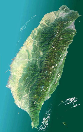
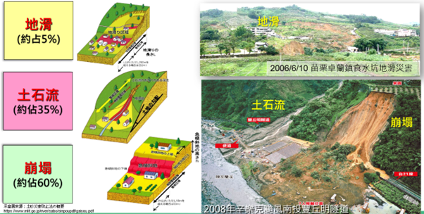
Taiwan's landscape is primarily composed of mountains and hills, accounting for 74% of the land, with plains making up 26%. The combination of steep slopes, concentrated rainfall, loose geological structures, and human development activities results in frequent slope disasters. [cite_start]These hazards are collectively influenced by topography, soil, climate, and land-use practices, often manifesting as 『debris flow』 [cite: 34][cite_start], landslides, and 『landslide』 [cite: 300] (地滑), posing a threat to transportation networks, settlements, and agriculture.

Main Challenges Faced:
  • Global climate change.
  • Normalization of disasters.
  • Rainfall volume and intensity are often extremely high.
  • High mountains, steep slopes, and fractured geology.
  • [cite_start]
  • Frequent landslides and 『debris flows』[cite: 34].
臺灣地圖
Map of Taiwan
2001年桃芝颱風南投郡坑村及上安村土石流
[cite_start]『Debris flow』 [cite: 34] in Junkeng and Shang'an Villages, Nantou County, caused by Typhoon Toraji in 2001.
1996年賀伯颱風南投豐丘村土石流
[cite_start]『Debris flow』 [cite: 34] in Fengqiu Village, Nantou County, caused by Typhoon Herb in 1996 (Photo provided by Hsieh Chin-Te).
1999年921地震後南投九九峰崩塌
Collapse of Jiujiu Peak in Nantou County after the 921 Earthquake in 1999.
Types of Slope Hazards

[cite_start]Slope hazards primarily comprise three major categories: 『debris flow』 [cite: 34][cite_start], landslides, and 『landslide』 [cite: 300] (地滑). These disasters are often triggered by natural factors like torrential rain or earthquakes, and are further influenced by topography, soil, and human activity. Understanding the causes and characteristics of these hazards is crucial for developing effective disaster prevention strategies and mitigating threats to life and property.

坡地災害類型
Large-scale Landslide/Collapse Disasters

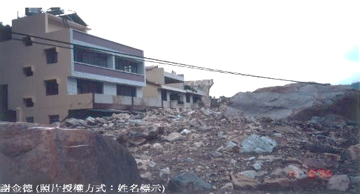
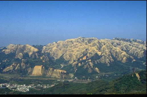
A large-scale landslide/collapse disaster refers to the sudden and massive fall of earth and rock over a short period, causing severe destruction to areas below. These disasters are typically triggered by heavy rainfall, earthquakes, or human activities, and are influenced by factors such as topography, soil, and vegetation. Large-scale landslides/collapses not only threaten the safety of life and property but can also lead to transportation disruption and environmental damage.

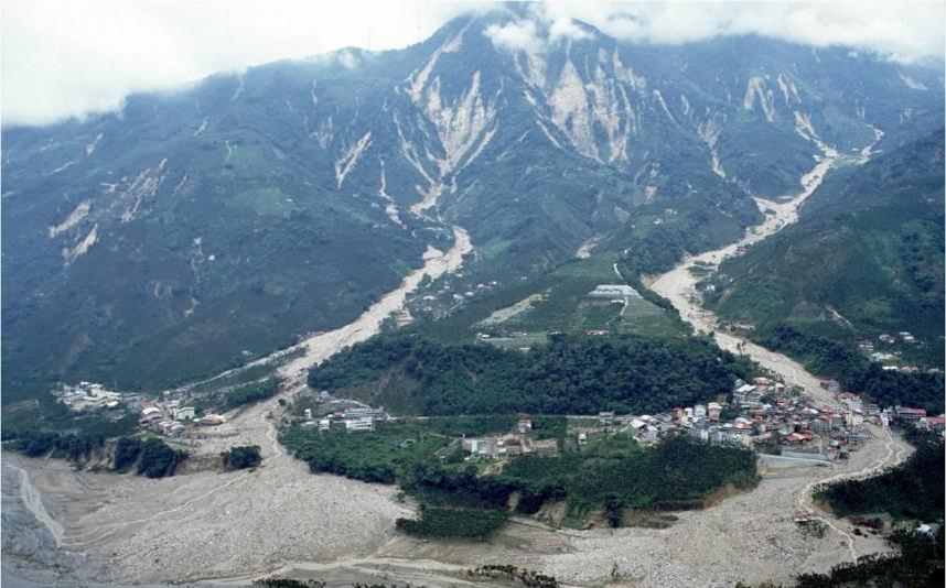
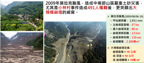
[cite_start]Typhoon Morakot in 2009 caused severe 『sediment-related disasters』 [cite: 53] in the mountainous regions of central and southern Taiwan. The subsequent Hsiaolin Village incident, which resulted in 491 fatalities, further highlighted the threat of large-scale landslides/collapses.

大規模崩塌災害
Predisposing Factors and Triggers of Slope Hazards
Predisposing Factors of Slope Hazards (Innate Conditions)

The predisposing factors (or innate conditions) of slope hazards refer to the inherent geological, topographical, and environmental factors that affect slope stability, such as rock layer characteristics, geological structure, slope angle, and soil composition.

  • Topographical Conditions: Areas with steep slopes are more susceptible to slope hazards, particularly those located in fault zones or regions with specific geological structures (e.g., 『dip slopes』).
  • Geological Structure: The composition and structure of rock strata on a slope, such as a 『dip slope』 formed by interbedded shale and sandstone, can easily retain moisture, which reduces the friction between the rock layers and often leads to sliding.
  • Soil and Rock Characteristics: The looseness of the soil and the degree of rock joint development both affect slope stability.
  • Hydrological Conditions: Regional hydrological characteristics, such as groundwater infiltration and the accumulation of rainwater, influence both soil moisture content and pressure.
Triggers of Slope Hazards (Triggering Factors)

Triggers are external forces or events that initiate an actual disaster under predisposing conditions. The most common triggers include heavy rainfall (e.g., typhoons and torrential rains), earthquakes, weathering, and inappropriate human activities (e.g., deforestation and mountain development). [cite_start]These factors reduce slope stability, leading to the occurrence of landslides, 『landslide』 [cite: 300] (地滑)[cite_start], and 『debris flows』[cite: 34].

  • Rainfall: [cite_start]Abundant rainfall, especially during typhoons and heavy downpours, infiltrates the soil, increasing the 『pore water pressure』 [cite: 140] and reducing soil stability. [cite_start]This is the most common trigger for landslides and 『debris flows』[cite: 34].
  • Earthquakes: [cite_start]Seismic shaking causes 『differential settlement』 [cite: 98] [cite_start]of the ground and loosens soil and rock, which are critical factors in triggering large-scale landslides and 『landslide』 [cite: 300] (地滑).
  • Weathering: Long-term weathering processes, such as wind, rain erosion, and freeze-thaw cycles, gradually decompose and disintegrate rock and soil, reducing their cohesion and making the slope vulnerable.
  • Human Disturbances:

    Deforestation and Overdevelopment: Removing vegetation reduces the soil's protective cover and drainage capacity, increasing the risk of slope sliding.

    [cite_start]

    Engineering Activities: Activities such as road construction, mountain development, poor construction of retaining walls or 『tie-backs』[cite: 316], and the improper disposal of construction waste can all compromise slope stability, and may even involve cutting away the toe of the slope, leading to a loss of support.

  • Vegetation Destruction: Events like forest fires can lead to the loss of vegetation and may also remove the protective layer of topsoil.
[cite_start]
Case Studies of Compound 『Sediment-related Disasters』 [cite: 53]

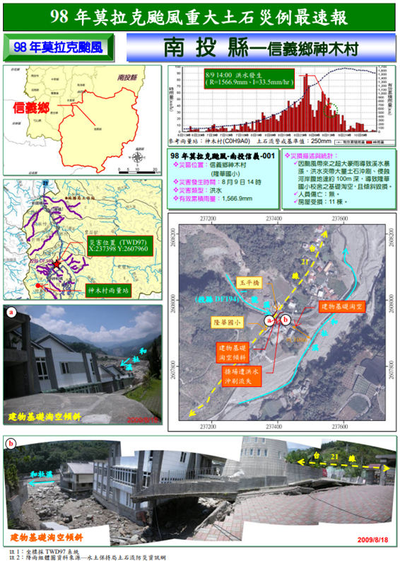
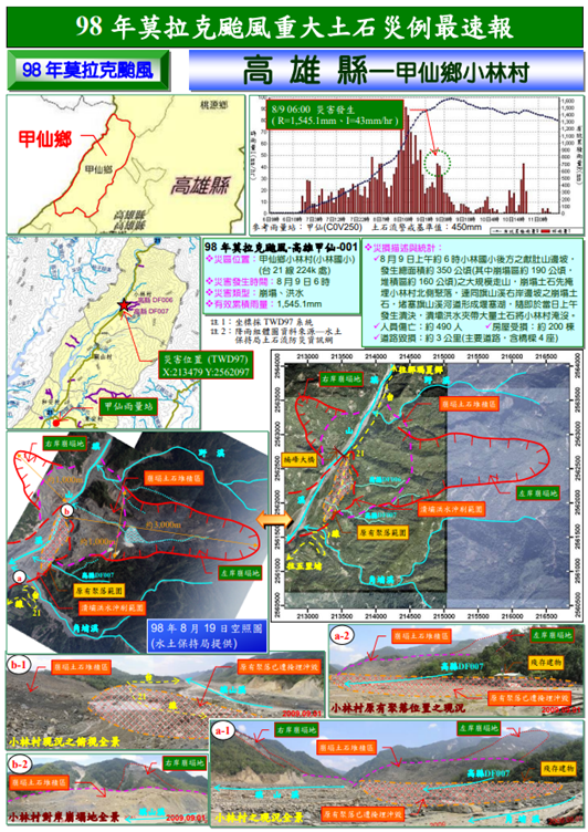
[cite_start]Presented below are two case studies of compound 『sediment-related disasters』 [cite: 53] in Taiwan: the Shenmu Village and Hsiaolin Village incidents. These cases illustrate the severity of slope hazards, their impact on communities, and underscore the importance of disaster prevention and response measures.

Shenmu Village Case Study
神木村案例
Hsiaolin Village Case Study
小林村案例
References (Delete before official launch)

1. [cite_start]『Debris Flow』 [cite: 34] & [cite_start]『Debris Flow』 [cite: 34] Disasters

https://246.ardswc.gov.tw/Info/Debris_Definition

2. [cite_start]Characteristics of 『Debris Flow』 [cite: 34]

https://246.ardswc.gov.tw/Info/Debris_Introduction

3. [cite_start]Presentation P12 『Debris Flow』 [cite: 34] Occurrence Conditions

https://246.ardswc.gov.tw/Service/DownloadTeachCase

頁面頂端

分享與工具列