Promoting Disaster-Resilient Communities
Definition
A disaster-resilient community is one capable of comprehensive disaster management. It is a sustainable community that can reduce disaster-forming factors before an event, conduct emergency response and mutual aid during a disaster, and achieve swift recovery and reconstruction afterward.
Every community member desires a safe and comfortable living environment. The goal of a disaster-resilient community is to establish a "safe and secure" area, which requires three key elements:
- The capacity to lower the probability of disaster occurrence.
- The ability to withstand disaster impacts, immediately respond, and minimize losses.
- The potential for rapid post-disaster recovery, reconstruction, and continuous development.
Through community empowerment, disaster-resilient communities consolidate collective strength and reduce the chances of a disaster by implementing mitigation and prevention measures. Should a disaster occur, residents are equipped to prevent the situation from escalating, minimize losses, and promptly initiate recovery and reconstruction efforts.
Importance
Through proactive, autonomous, and aware community actions, residents' crisis awareness and disaster prevention knowledge are enhanced. Simultaneously, internal and external community resources are integrated to facilitate the planning of comprehensive and suitable disaster relief and response strategies tailored to the community's needs and characteristics.
Implementation Model
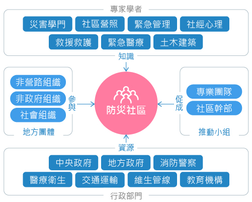
With the Village/Borough Office or Community Development Association as the driving force, the model integrates community organizations (such as patrol teams, neighborhood mutual aid teams, Phoenix volunteers, production units, women's groups, etc.) and external agencies (such as Township/District Offices, Fire Departments, Public Health Centers, Police Stations). These groups collaborate, utilizing their respective strengths, to enhance resident interaction and participation. Professionals provide expert knowledge on disaster prevention and relief, assist communities in analyzing their hazard environment, and formulate solutions to disaster challenges. Facilitators then lead and support disaster-resilient community activities, responsible for guiding participants to think, discuss, offer opinions, and mediate conflicts arising from differing views.
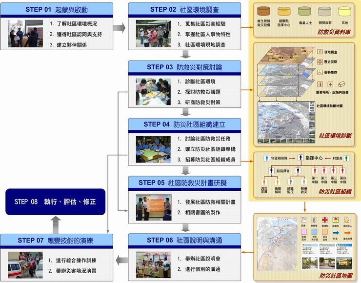
Implementation Procedures
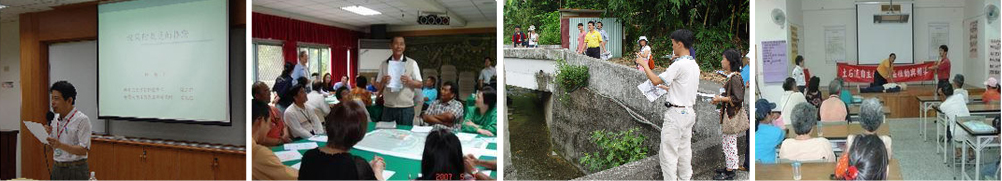
The process of establishing a disaster-resilient community requires "public participation." Through the learning of disaster and disaster relief knowledge and techniques, residents strengthen their preparedness and skills. Furthermore, by promoting mitigation and prevention measures, the community can reduce potential disaster-forming factors and lower the chance of a disaster occurring.
1
Procedure
Education and Advocacy
Summary /
Hold community briefing sessions to enhance residents' disaster awareness.
2
Procedure
Environmental Assessment
Summary /
Collect community disaster experiences, investigate the natural and social environment, disaster relief resources, conduct on-site surveys and mapping, integrate the results of various community environmental investigations, identify vulnerable and safe areas, and jointly discuss countermeasure strategies.
3
Procedure
Community Mobilization
Summary /
Establish a disaster prevention and relief organization, assign tasks, and formulate a community disaster prevention and relief plan by effectively integrating resources based on community characteristics and needs. This plan serves as the basis for the future implementation and realization of the disaster-resilient community. Furthermore, through community briefing sessions and individual communication, disseminate the achievements and information of the disaster-resilient community to the public, encouraging broader participation to enhance the community's overall disaster readiness capacity.
4
Procedure
Disaster Preparedness
Summary /
Considering the types of disasters that may occur in the community, review disaster prevention and relief supplies, connect with relevant local administrative units and non-governmental organizations, and conduct disaster drills focusing on the basic skills required in areas most susceptible to disaster impact, thereby strengthening the community's response capability.
Disaster Preparedness Tasks
Families should prepare disaster supplies in advance. The community, in turn, should complete evacuation and shelter organizational arrangements, prepare shelters, set up simple rain gauges for autonomous disaster monitoring, and finalize drills before the flood season. By diligently completing these disaster preparedness tasks, residents can remain calm and respond effectively when a debris flow occurs.
- Monitor the environment and notify the township office of disaster conditions.
- Use radio communication to compile the number of evacuees and disaster status.
- Promote guidance for debris flow evacuation and sheltering.
- Divide areas and assist residents in evacuating to shelters.
- Assist residents in registering at shelters.
- Set up service stations to provide assistance and consultation.
- Rescue and search operations for affected residents.
- Remove obstacles to assist escape.
- Set up warning signs and traffic control.
- Manage residents unwilling to evacuate.
- Maintain public order in the disaster area and shelters.
- Triage, basic first aid, and transport for severely injured.
- Psychological counseling support.
- Support from emergency medical vehicles.
- Stockpile medicine, essential supplies, food, and drinking water.
- Assist in the distribution of essential supplies, food, and drinking water.
- Material registration, record-keeping, storage, and distribution.
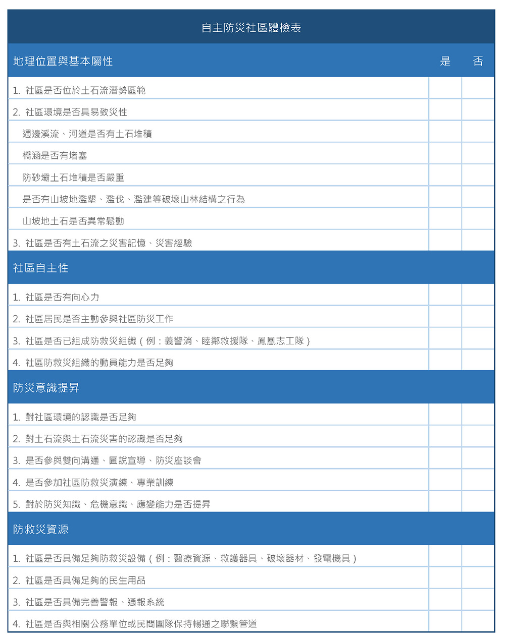
Self-Assessment Checklist
Check whether your community is located in a 『debris flow potential area』. Are all disaster preparedness tasks complete? Does the community meet the necessary conditions for a debris flow-resilient community?
Download Self-Assessment Checklist for Disaster-Resilient Communities
Evacuation and Sheltering Planning
When the patterns of slope disasters exceed current predictability, and modern engineering controls prove inadequate or too slow, promoting disaster prevention concepts and evacuation strategies in 『debris flow potential area』s is the most pressing task. It involves directly educating the public on how to inspect preparedness measures during normal times, how to anticipate disasters before they strike, how to evacuate during an event, and how to seek assistance and rebuild afterward. The goal is to build consensus that "disaster relief" begins with "disaster prevention," instilling the concept that residents must "help themselves before others can help." In addition to providing post-disaster logistical support, all levels of government should supply sufficient and detailed disaster information and knowledge to grassroots citizens, enhancing crisis awareness and disaster instincts, fostering teamwork, integrating internal and external resources, and strengthening pre-disaster readiness.
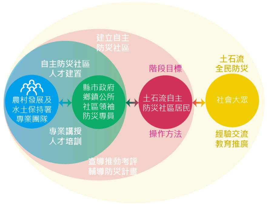
Following Typhoon Toraji, the Rural Development and Water Conservation Agency of the Ministry of Agriculture specifically intensified the promotion of debris flow disaster evacuation and sheltering work. This involved formulating the "debris flow Disaster Evacuation and Sheltering Planning Procedure," focusing on-site surveys on the likely disaster conditions, scale, and extent of impact. This is integrated with relevant survey and research outcomes, such as simple methods for detecting abnormalities in man-made structures, debris flow disaster distribution, crisis judgment and handling methods, evacuation routes, shelters, safe zones, emergency rescue communication systems, and general knowledge of hillside areas. Through this, a local debris flow disaster evacuation and sheltering mechanism is planned, collectively aiming for regional prevention, avoidance, and mitigation measures, and enhancing public readiness and response capabilities when a disaster strikes.
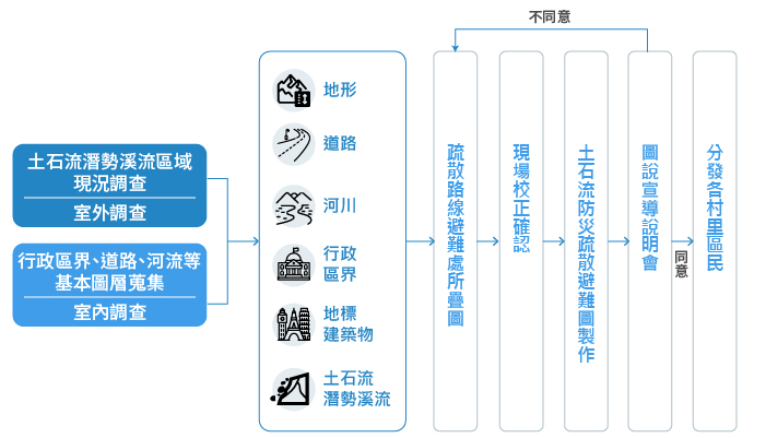
Evacuation and Sheltering Planning Tasks
Current Status Investigation
Obtain a basic photogrammetric map (1/5,000 or 1/10,000) for on-site investigation and preliminary planning on the map. Contact the Village/Borough Chief to obtain contact information for protected households within the potential area. Interview local residents affected by past debris flows regarding their refuge areas and safe locations, assess their safety, or assist in locating evacuation routes, shelters, and emergency helicopter landing sites.
Basic Layers
The map size is primarily A0. The basic layer is the 1:25,000 cadastral topographic map, which includes data such as roads, rivers, landmarks, administrative boundaries, contour lines, and 『debris flow potential area』s.
Evacuation Route and Shelter Overlay Mapping
Superimpose the surveyed data of evacuation routes, shelters, and important buildings onto the basic map to produce the preliminary draft of the Evacuation and Sheltering Route Map.
On-site Verification and Confirmation
Review and revise the preliminary draft of the Evacuation and Sheltering Route Map with the Village/Borough Chief or Clerk.
Production of the debris flow Disaster Evacuation and Sheltering Map
Finalize the map draft, complete the overlay, and archive it in a unified format. In addition to evacuation and sheltering data, the map includes contact information for disaster reporting, police, fire, medical services, village/borough officials, and shelters, as well as various pieces of disaster prevention knowledge.
Map and Advocacy Briefing Session
Present the completed Evacuation and Sheltering Route Map to the Village/Borough Chief and residents in a face-to-face session for explanation and advocacy. The final debris flow Disaster Evacuation and Sheltering Map is then produced after the Village/Borough Chief signs off on the content.
Distribution to Village/Borough Residents
Complete all necessary indoor processing and outdoor investigation tasks and distribute the final map to residents of villages and townships located in 『debris flow potential area』s.
Principles for Planning Implementation
- During the process from planning to completion, frequently conduct joint on-site surveys with the Village Chief, Village Clerk, or residents of the planning area to communicate work objectives and planning details.
- Through the map and advocacy briefing sessions, provide local residents with a better understanding of debris flow disasters using information brochures and manuals.
- Promptly address the valuable feedback provided by residents after the map and advocacy briefing sessions.
- Cooperate with the debris flow disaster evacuation and sheltering drills organized by the Rural Development and Water Conservation Agency of the Ministry of Agriculture to transform planning results into actual action, which further helps residents understand the evacuation and sheltering routes.