The Debris Flow and Large-Scale Landslide Disaster Emergency Response Team was established by the Agency of Rural Development and Soil and Water Conservation, Ministry of Agriculture, to cope with debris flow and large-scale landslide disasters.
During typhoons and heavy rainfall, the team monitors rainfall, conducts debris flow warning analysis through debris flow observation stations and satellite transmission systems, issues timely warning forecasts, and coordinates response measures with central and local disaster response centers to protect the public's lives and property.
Timing of Establishment
When the Central Weather Administration issues a typhoon warning or a heavy rain advisory of torrential rain level, the Agency of Rural Development and Soil and Water Conservation will determine the necessity of activating the Debris Flow and Large-Scale Landslide Disaster Emergency Response Team.
Based on actual needs, the team is activated in three levels (Level 1 to 3), with different staffing, for 24-hour monitoring and operation.
Purpose of Activation
The most important purpose and function of activating the Debris Flow and Large-Scale Landslide Disaster Emergency Response Team is to coordinate with the establishment of central and local government disaster response centers, handle response measures for debris flow and large-scale landslide disasters, and issue timely debris flow and large-scale landslide warning forecasts.
Response Operation Procedure
Step 1: Pre-judgment - Meteorological Information Analysis
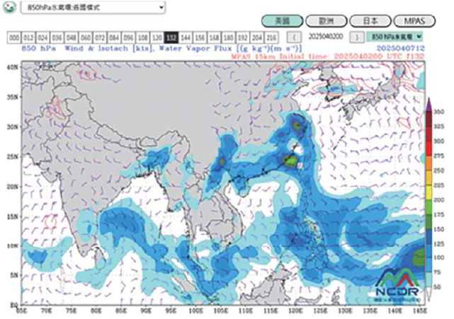
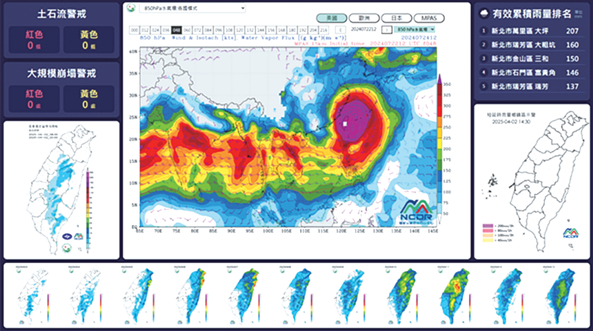
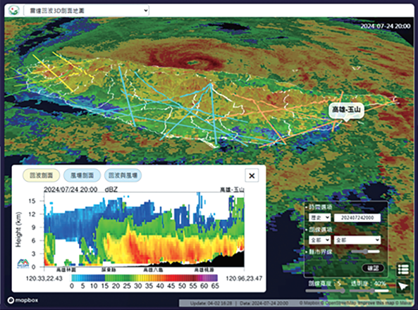
Upon receiving heavy rain advisories or typhoon movement information, the Emergency Response Team immediately starts monitoring, utilizing the meteorological visualization dashboard and radar 3D cross-section to grasp heavy rainfall areas, pre-judge risk zones, and serve as the basis for warnings and response actions.
Step 2: Deployment - On-site Real-time Monitoring
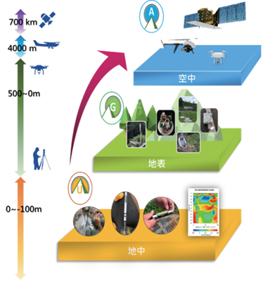
Debris Flow Monitoring
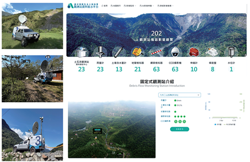
The Agency has established over 200 debris flow, large-scale landslide observation stations, and automatic rain gauges across Taiwan,
and is equipped with mobile observation vehicles for flexible, round-the-clock observation missions. The relevant data is integrated into the Observation Station Data Display Platform.
Large-Scale Landslide Monitoring
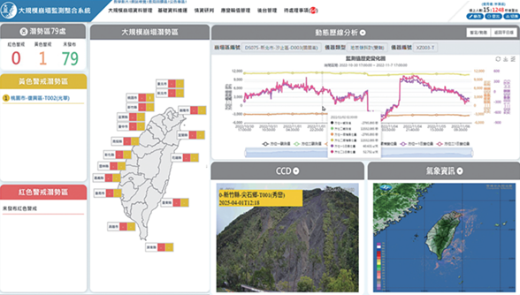
The "Large-Scale Landslide Monitoring Integration System" possesses intelligent monitoring and warning issuance functions,
capable of integrating information from various monitoring instruments within the warning area to instantly grasp the latest dynamics and quickly respond to disasters.
Step 3: Early Warning - Warning Issuance and Communication
★ Warning Issuance Method and Response Actions
Establish warning and response mechanisms, combining forecasting, observation, and notification, to grasp the disaster situation, issue warnings in real-time, and enhance disaster prevention effectiveness.
Illustration: Schematic Diagram of Warning Issuance Process and Response Actions https://www.ardswc.gov.tw
★ Warning Issuance Notification, Reminder
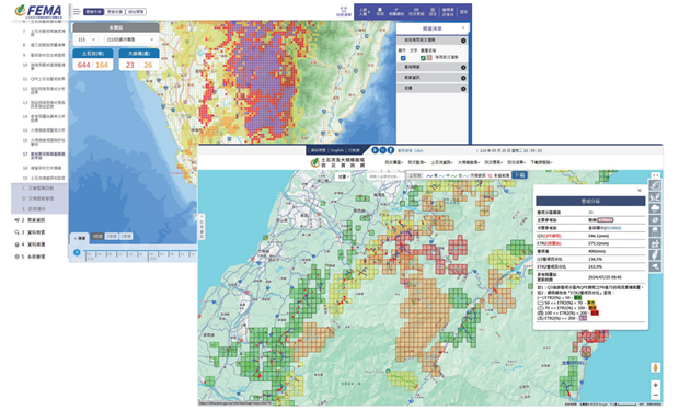
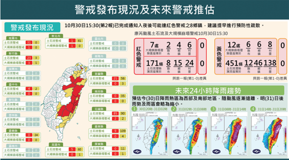
Debris flow and large-scale landslide warnings are divided into Yellow and Red Alerts. Upon issuance, all levels of government response units are simultaneously notified, and a cell broadcast is sent directly to local residents. To enhance decision-making information, Red and Yellow Alert projections for the next 48 hours are provided based on the quantitative precipitation forecast from the Central Weather Administration.
Illustration: Schematic Diagram of Current Warning Status and Future Warning Projection
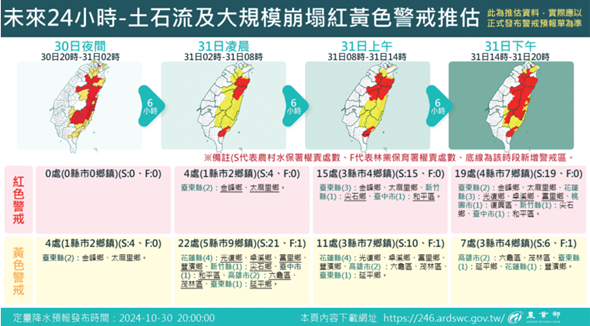
Illustration: Schematic Diagram of Current Warning Status and Future Warning Projection for the Next 24 Hours
★ Warning Issuance and Transmission
Debris flow and large-scale landslide warnings are divided into Yellow and Red Alerts. Upon issuance, all levels of government response units are simultaneously notified, and a cell broadcast is sent directly to local residents.
Red and Yellow Alert projections for the next 48 hours are also provided based on the quantitative precipitation forecast.
Yellow Alert
【Issuance Conditions】
Predicted Rainfall > Warning Threshold
【Response Actions】
Local government should advise on evacuation and relocation
Preventive evacuation is recommended for those with mobility issues and those requiring regular medical attention
Red Alert
【Issuance Conditions】
Actual Rainfall > Warning Threshold
【Response Actions】
Local authorities should advise or enforce their evacuation and provide proper shelter
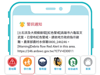
The customized cell broadcast page provides local residents in the warning area with information such as real-time local rainfall, shelters, important contact numbers, and disaster prevention supplies.
It also supports multiple languages (Chinese, English, Vietnamese, Indonesian, etc.).
Customized Cell Broadcast Page
Customized Cell Broadcast Page - Chinese Version
Alert Dissemination Protocol
Step 4: Response - Disaster Situation Management and Handling
★ Disaster Information Collection
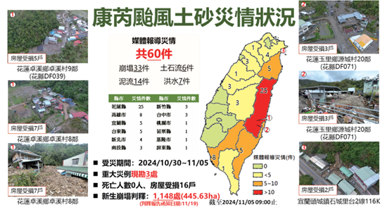
Real-time collection and statistics of disaster situations to grasp the overall status, and preparation of investigation reports for public release on the Disaster Prevention Information Website for reference by all sectors.
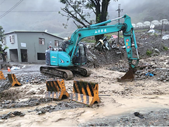
★ Emergency Clearing/Repair and Emergency Handling
When major sediment disasters occur, quickly grasp the disaster situation, simultaneously activate heavy machinery standby and emergency repair operations, to reduce the risk of secondary disasters.
Illustration: Emergency Clearing during Typhoon Kong-rey in Dongpu Village, Xinyi Township, Nantou County
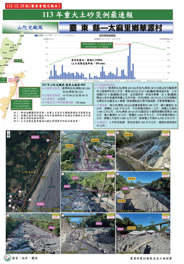
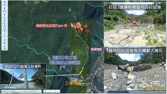
Illustration: Post-Disaster Emergency Handling and Prevention Measures - Sanjhan South Creek (Hualien County DF174)
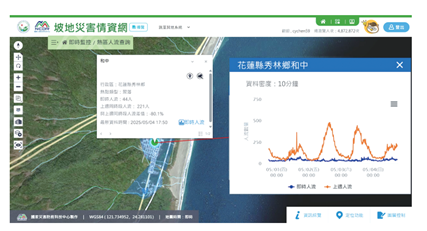
★ Evacuation Flow Monitoring
Monitor crowd flow changes through mobile signal data, comparing the difference between current and previous week's simultaneous crowd flow data, to quickly grasp the local evacuation situation after a warning is issued.
Illustration: Schematic Diagram of Evacuation Flow Monitoring Visualization
Step 5: Decision-making - Decision Support and Scenario Projection
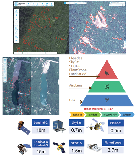
★ Interpretation of New Landslides
Satellite imagery interpretation of new landslides is conducted for areas under Red or Yellow Debris Flow Alerts or areas with seismic intensity 5 strong or higher.
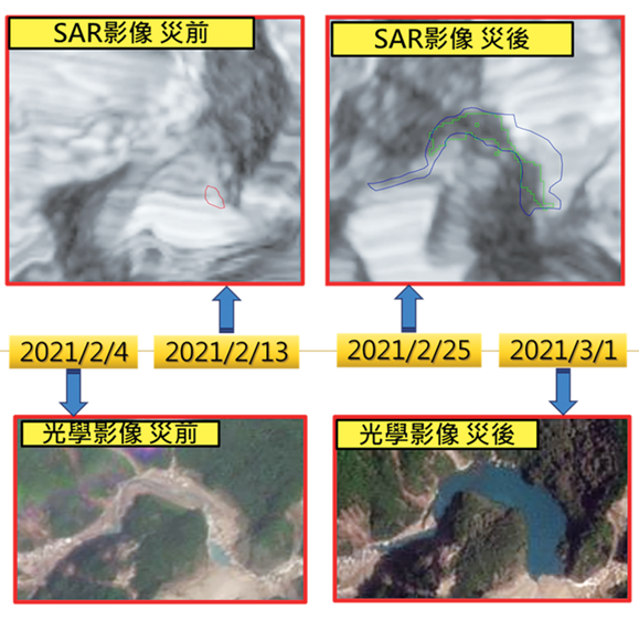
★ Detection of Barrier Lakes Using Optical and Radar Satellites
Utilize the cloud-penetrating capability of SAR satellite imagery to detect barrier lakes, supplemented by optical remote sensing imagery for confirmation.
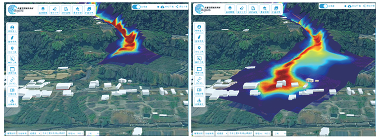
★ SDF Debris Flow Simulation
Utilize a simple debris flow model (SDF-model) to quickly simulate the impact area and dynamics of new landslides, serving as a reference for debris flow disaster prevention and response decisions.
Illustration: 2023 Typhoon Khanun Disaster Case: St. Benedict Gas Station, Nanfeng Village, Ren'ai Township, Nantou
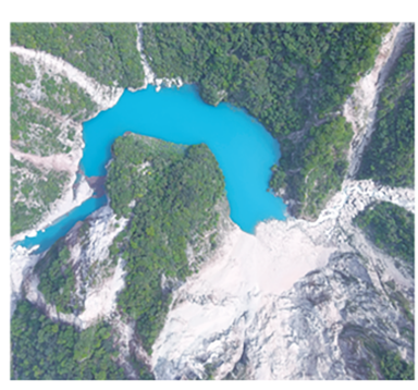
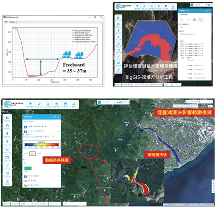
★ Barrier Lake Outburst Flood Simulation
Utilize DEM and cut-and-fill analysis to determine the barrier lake volume, and use a numerical model to simulate the outburst impact.
Illustration: Barrier Lake On-site Photo
Illustration: Barrier Lake Outburst Numerical Model Simulation Image