According to the "Action Plan for Large-scale Landslide Disaster Prevention" completed by the National Science and Technology Center for Disaster Reduction, a large-scale landslide refers to a landslide area exceeding 10 hectares, or a soil volume reaching 100,000 cubic meters, or a collapse depth of more than 10 meters. This type of deep-seated landslide is close to a high-speed movement of a landslip.
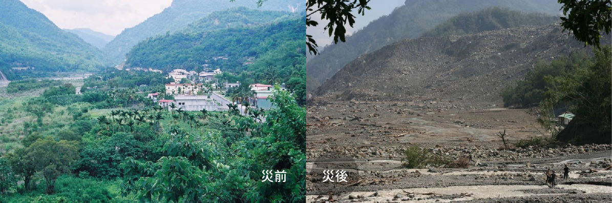
Typhoon Morakot on August 9, 2009, caused the collapse of Xiantu Mountain in Xiaolin Village, resulting in 491 deaths (Figure 1-1). Japan first proposed the term "deep-seated failure," which Taiwan indirectly adopted and changed to "deep-seated landslide." After multiple discussions, considering the scale of the disaster, the term was further changed from "deep-seated landslide" to "large-scale landslide."
(Figure 1-1)Photos of Xiaolin Village before and after the disaster。
A large-scale landslide is not equal to a large-scale landslide disaster; a large-scale landslide is a "**natural phenomenon**,"
but if a large-scale landslide occurs, leading to casualties, damage to buildings, bridges, and public facilities,
causing loss of life or property, it can be called a "**large-scale landslide disaster**" (Figure 1-2).
(Figure 1-2)Large-scale Landslide Disaster
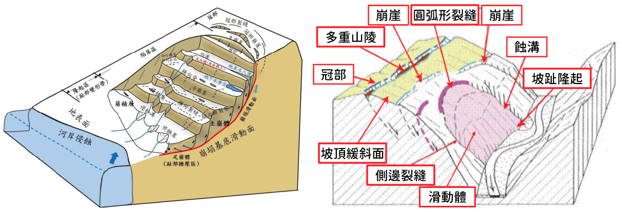
Characteristics of Large-scale Landslides
Topographical Features
Except for special geological conditions (such as dip slopes), the sliding surface of a large-scale landslide does not form suddenly,
but occurs after a long period of gestation and evolution. During this process, topographical signs are left on the surface.
Gently sloping surface at the top of the slope
Scarp, reverse scarp, fissure
Double or multiple ridge lines
Linear depression
Arcuate sliding mass
Toe bulging
Erosion grooves and fissures on the slope surface and sides
Rock mass creep phenomenon
Other old landslide topographies
Topographical Features of Large-scale Landslides (Data Source: Central Geological Survey, MOEA and National Science and Technology Center for Disaster Reduction)
Causes of Occurrence
There are four types of factors affecting slope stability (Turner and Schuster, '85)
1
Geological Causes
Weak strata
High sensitivity of strata
Weathering of strata
Strata subjected to shear stress
Presence of joints or fissures in strata
Rock mass with unfavorable discontinuity attitudes (such as bedding, foliation, etc.)
Strata with unfavorable structural discontinuity attitudes (such as faults, unconformities, contact surfaces, etc.)
Large difference in strata permeability
Large difference in strata stiffness (e.g., dense, high-rigidity material overlying plastic material)
2
Geological, Topographical, and Morphological Factors
Plate or volcanic uplift
Glacial unloading rebound
Toe erosion by floodwater
Toe erosion by waves
Toe erosion by glaciers
Lateral boundaries of slopes subjected to scour
Subsurface erosion (dissolution, piping)
Natural accumulation load on slope or crest
Removal of vegetation (forest fire, drought)
3
Physical Causes
Torrential rain
Rapid snowmelt
Long-term abnormal rainfall
Rapid drawdown of water level (flood recession, ebb tide)
Earthquake
Volcanic eruption
Thawing
Weathering due to freezing and thawing
Weathering due to shrinkage and expansion
4
Human Causes
Excavation of slopes or toes
Man-made increase in load on slopes or crests
Poor road drainage
Water impoundment or reservoir discharge
Deforestation, logging
Irrigation
Mining
Artificial vibration
Water leakage from public pipelines
Signs of Occurrence
Observing whether the trees are tilted.
Appearance of new, consistent, and continuous fissures in roads, retaining walls, or structures.
Based on data from on-site monitoring instruments, including those measuring rainfall, hydrology, stress, inclination, and displacement. Such as a sharp rise or sudden drop in groundwater level, water seepage on the slope surface, water leakage from fissures, or the appearance of systematic fissures on the surface, or accelerated sub-surface displacement.