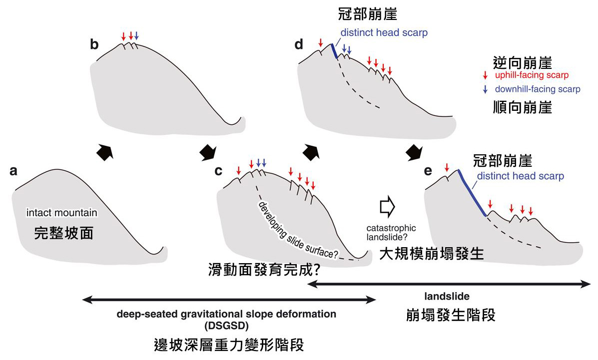
Large-scale landslides have complex mechanisms and are time-dependent (Figure 4-1). Generally, when a slope is affected by gravity, it gradually deforms, and various micro-topographic features begin to appear on the slope surface (b). As deformation continues under the influence of gravity, the amount of deformation will increase, and internal failure surfaces within the slope will also begin to develop (c).
When a major event (typhoon, heavy rain, earthquake, etc.) occurs, because the material has already deformed, the overall strength is relatively weaker, which may lead to localized failure (d) or a single large-scale sliding event (e). Conversely, under localized failure conditions (d), the sliding surface continues to develop under the influence of gravity and may also transition to a single large-scale sliding event (e) during a major event.
Figure Caption: Figure 4-1 Large-scale Landslide Occurrence Process (Source: Kaneda ad Kano, 2017)
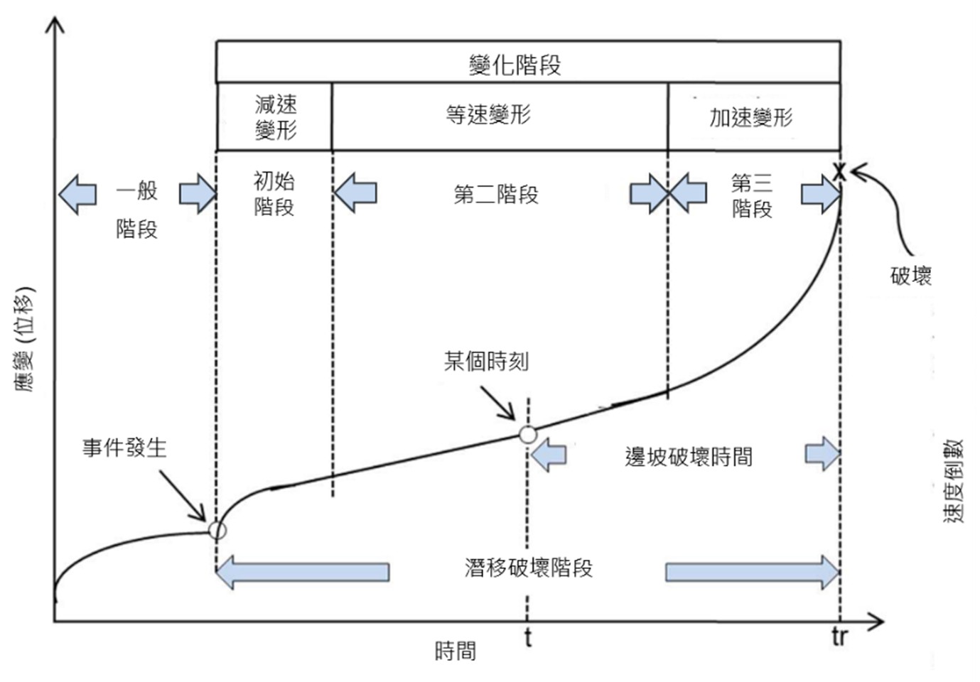
After signs of deformation appear on the slope, major events will induce an increase in the amount of deformation (trigger condition). This process is generally represented by a strain-time curve (Figure 4-2).
In Figure 4-2, the increase in deformation can be divided into stages based on the rate of deformation: decelerating deformation, constant velocity deformation, and accelerating deformation. Therefore, the establishment of an alert system should consider different stages. Generally, the determination of the trigger condition can use rainfall and on-site monitoring data as indicators for event occurrence.
Rainfall Alert Thresholds
Method for Selecting Alert Thresholds
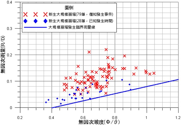
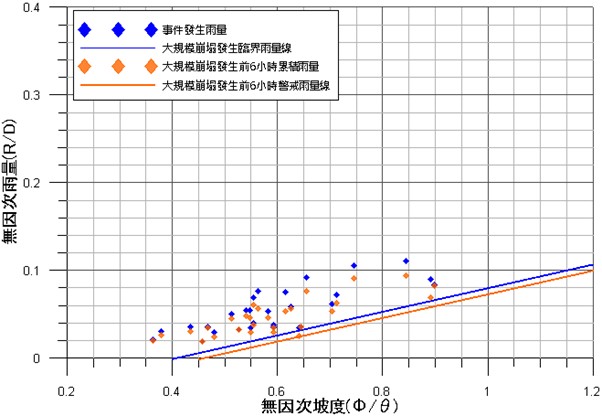
To analyze the rainfall triggering large-scale landslides, it is necessary to analyze data from existing occurrence cases. The Agency of Rural Development & Soil and Water Conservation (ARDSWC) analyzed signals from the broadband seismometer network to identify 28 newly formed large-scale landslide cases with known occurrence times during the period from 2001 to 2016 (blue dots in Figure 4-3). The corresponding accumulated rainfall at the time of occurrence was analyzed to establish the critical rainfall line for large-scale landslide occurrence (blue line in Figure 4-3), which serves as the basis for evaluating the occurrence conditions in potential areas. An additional 79 large-scale landslide cases (red dots in Figure 4-3) were used for validation to confirm the rationality of the critical rainfall line. Furthermore, considering the preparations for evacuation and shelter, the critical rainfall for occurrence was converted into the large-scale landslide alert rainfall line (orange line in Figure 4-4) to serve as a reference for setting alert values.
Figure Caption: Figure 4-3 Critical Rainfall Line for Occurrence Using Effective Accumulated Rainfall
Figure Caption: Figure 4-4 Large-scale Landslide Alert Rainfall Line Considering Evacuation Time
On-site Monitoring Alert Thresholds
Generally, monitoring results are used to set emergency management values. However, if the monitoring time is insufficient to determine the threshold, it is recommended to refer to domestic and international literature to set the alert values. Once sufficient monitoring time is available, the threshold can be determined based on statistical analysis of each monitoring result. Commonly used reference values are summarized in Table 4-1.
Table 4-1 Commonly Used Deformation and Strain Management Criteria
Commonly Used Deformation and Strain Management Criteria
Monitoring Item
Strain Management Criteria
Source/Unit
Ground Extensometer
Classification of activity level for potential sliding areas based on average deformation, including daily deformation
0.5 mm/day ~ 20 mm/day,
or monthly deformation
0.5 mm/month ~ 300 mm/month
Chinese Soil and Water Conservation Society, 1999
Express Highway Research Foundation Of Japan, 1988
Japan Highway Public Corporation Old Survey Guidelines, 1992
Flentje and Chowdhury, 2002
Japan Landslide Society, 1978
Ground Inclinometer
5 sec/day ~ 50 sec/day
Chinese Soil and Water Conservation Society, 1999
Express Highway Research Foundation Of Japan, 1988
Japan Highway Public Corporation Old Survey Guidelines, 1992
In-place Inclinometer
0.5 mm/day ~ 10 mm/day
Chinese Soil and Water Conservation Society, 1999
Express Highway Research Foundation Of Japan, 1988
Japan Highway Public Corporation Old Survey Guidelines, 1992