Understanding Debris Flow and Large-scale Landslides
Debris Flow
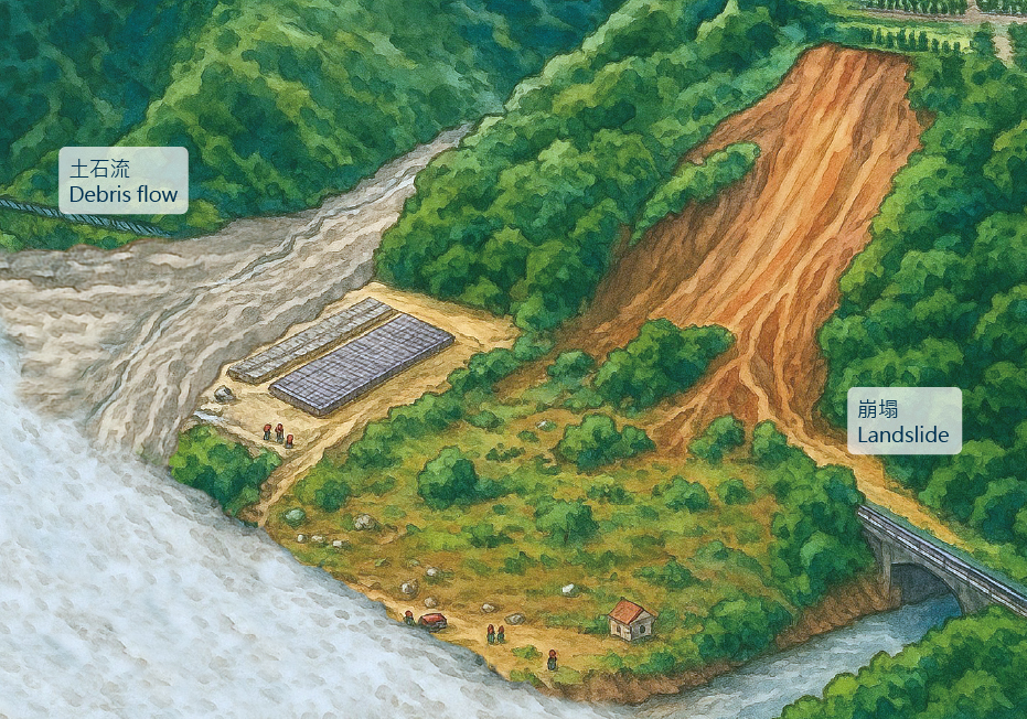
When heavy rainfall occurs or river channels are blocked, large amounts of mud, sand, and rocks rush down gulleys or streams, causing severe disasters.
★ Precursor Phenomena
Stream water turns turbid, water level rises or suddenly stops flowing, and abnormal sounds are heard.
Landslide
An unstable slope suddenly collapses due to factors like rainfall or earthquakes.
★ Precursor Phenomena
Possible signs include cracks appearing on the slope surface, increased rockfalls, and groundwater seepage.
Land Slip (Creep)
The entire land mass slowly slides due to the influence of groundwater, affecting a larger area.
★ Precursor Phenomena
Ground cracks, tilting of trees or utility poles, and deformation of buildings.
Large-scale Landslide
A large-scale landslide is defined if one of the following conditions is met:
The landslide area exceeds **10 hectares**
The volume of earth reaches **100,000 cubic meters**
The landslide depth is **10 meters or more**
★ Precursor Phenomena
Tilting of trees, cracks appearing in roads, retaining walls, or structures, rumbling sounds caused by vibration, sounds of cracking wood, and bulging of the slope foot.
Conditions for Debris Flow Occurrence
Conditions for Debris Flow Occurrence
Sufficient sediment
Steep enough slope
Sufficient rainfall
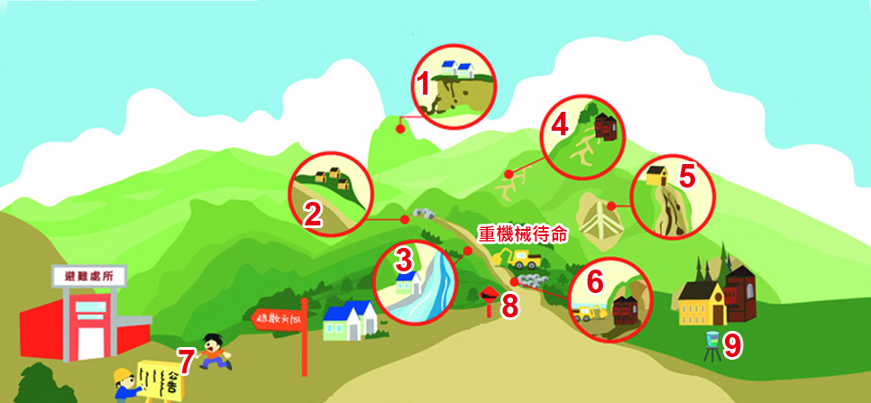
Locations Prone to Debris Flow Disasters
Collapse zones in the upper reaches
Areas prone to collapse on both banks of the stream
Alluvial fan area at the valley mouth downstream
Signs of Debris Flow Occurrence
Turbid stream water
Flow volume increases or decreases
A "GO" rumbling sound is heard
Debris Flow Evacuation Methods
Debris Flow Evacuation Principles
Evacuate to the local emergency shelter according to the debris flow disaster prevention map.
Try to use existing roads.
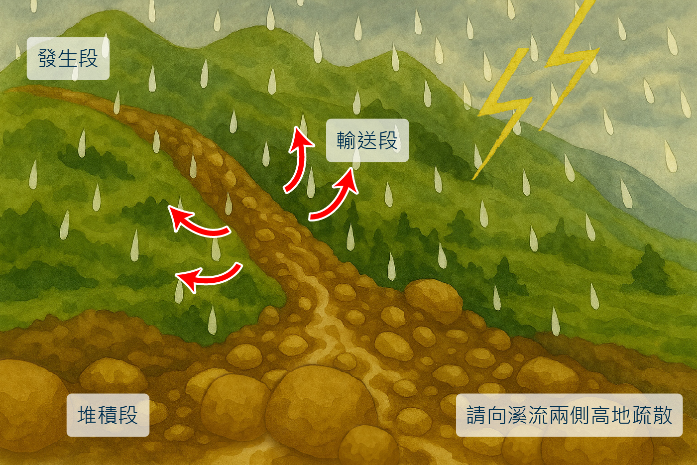
Evacuate towards high ground on both sides of the stream.
Do not cross potential debris flow streams.
Avoid passing through dangerous road sections or slope areas.
Key Point: When facing heavy rainfall, evacuate towards high ground on both sides of the stream, avoid descending towards the stream channel!
Diagram: Debris flow is divided into the origin area, transportation area, and deposition area based on terrain; during evacuation, retreat to high ground on both sides.
What to Do When Your Residential Area is Declared a Warning Zone
Pay attention to the issuance of Debris Flow and Large-scale Landslide Warnings
Red Warning
Please follow the arrangements of the township/city/district office and local police/fire department to evacuate to a safe location.
Issuance Condition: Actual rainfall > Warning threshold
Response Action: Local authorities should advise or force evacuation and provide appropriate resettlement.
Yellow Warning
Residents should observe environmental changes, continuously monitor the latest public broadcast news, and keep household communication channels open.
Local government should issue evacuation advisories.
Preventive evacuation is recommended for individuals with mobility issues and those requiring regular medical attention.
Evacuation Target: Protected households within the affected areas of potential debris flow and large-scale landslides, not the entire village or township.
Pay Attention to Disaster Prevention Information
Constantly Monitor Weather Forecasts
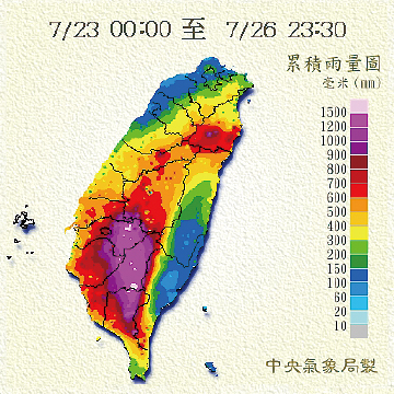
Typhoons are predictable; sufficient preparation beforehand can prevent disasters.
Debris Flow and Large-scale Landslide Disaster Prevention Information Website
Notification from Local Debris Flow Disaster Prevention Specialists
Join the "Debris Flow and Large-scale Landslide Disaster Prevention Information Website" LINE BOT
Open Cell Broadcast Customized Disaster Prevention URL
Provides Five Core Information Items:
Where the Warning Zone is Located
What I Should Do
Current Rainfall Situation
Recommended Disaster Prevention Supplies
Shelters and Phone Numbers
Typhoon Warnings
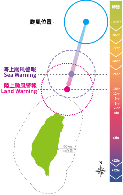
★ Sea Typhoon Warning
The sea warning shall be issued immediately 24 hours before the forecast 7-level wind radius of the typhoon may encroach upon the sea areas within 100 kilometers of Taiwan, Penghu, Kinmen, or Matsu. It is then issued every 3 hours, with additional releases if necessary.
★ Land Typhoon Warning
The land warning shall be issued immediately 18 hours before the forecast 7-level wind radius of the typhoon may touch down on the land of Taiwan, Penghu, Kinmen, or Matsu. It is then issued every 3 hours, with additional releases if necessary.