

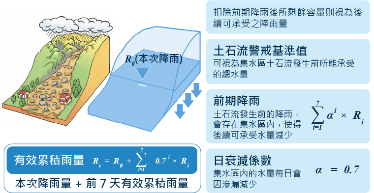
Method for Setting Debris Flow Warning Threshold
Debris Flow Warning Threshold
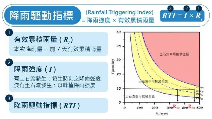
Simplified Method
- Based on the RTI values calculated from historical rainfall events, use RTI70 (70%) as the benchmark.
- Under the condition of rainfall intensity I = 10 mm/hr, the debris flow accumulated rainfall warning threshold R70 is inferred from the Rainfall Trigger Index threshold RTI70.
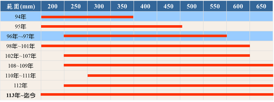
- Set 50mm as 1 grade interval, setting the debris flow warning threshold range with 200mm as the lower limit and 650mm as the upper limit (a total of 10 grade intervals).
Routine Update of Debris Flow Warning Threshold
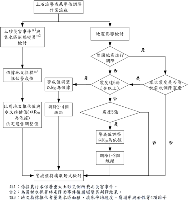
★ Standard Operating Procedure for Debris Flow Warning Threshold Update
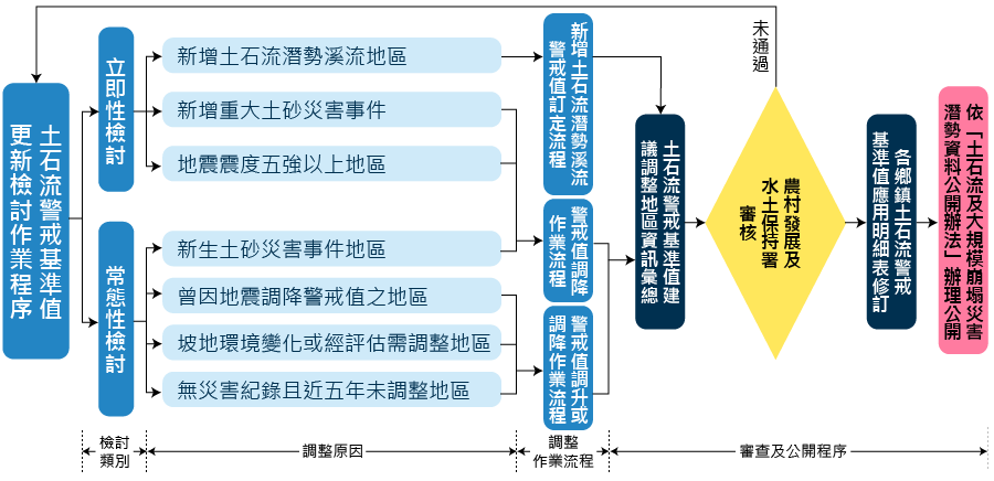
★ Routine Update of Debris Flow Warning Threshold
- Areas with New Sediment Disaster Events: Areas where sediment events occurred after the last warning threshold update but did not cause a disaster should still be evaluated for the necessity of a warning threshold adjustment.
- Areas with Slopeland Environmental Changes in Debris Flow Catchment Areas or Areas Assessed for Adjustment: Although no new debris flow or earthquake events have occurred in the area, if there are significant environmental changes in the catchment area (e.g., landslides caused by rainfall), or if an adjustment is deemed necessary after evaluation of new rainfall events, the debris flow warning threshold should be reviewed.
- Areas Where Warning Threshold Was Reduced Due to Earthquakes: For specific areas where the warning threshold was reduced due to an earthquake (and has not yet been restored to the original value), the new earthquake events and disaster occurrence should be re-evaluated annually to review the debris flow warning threshold.
- Areas with No Recorded Sediment Disaster and No Adjustment in the Past Five Years: Warning zones with no recorded sediment disaster and no warning threshold adjustment for five years or more must compare the current warning threshold with the analysis results of historical rainfall events. Locations where the difference between the current warning threshold and the analysis result is too large should be included in the routine review.
★ Immediate Review of Debris Flow Warning Threshold
- New Major Sediment Disaster Events: For areas where complex disaster events such as large-scale landslides and debris flow disasters occurred in the catchment area due to events like Typhoon Morakot in 2009 (Year 98 of the Republic of China calendar), immediate adjustment recommendations for the debris flow warning threshold should be proposed based on the situation in each affected area.
- Areas Affected by Earthquakes with Intensity 5 Strong or Higher (new earthquake events where the Peak Ground Acceleration (PGA) is above 80 gal and the Peak Ground Velocity (PGV) is above 30 cm/sec): Adjustment recommendations for the debris flow warning threshold should be proposed based on the situation in each affected area.
- Newly Added Debris Flow Potential Streams: If the newly added stream is within an existing debris flow warning zone, the need to update the current debris flow warning threshold should be reviewed, and updated immediately if necessary. If it is not part of an existing debris flow warning zone and needs to be newly added, the debris flow warning threshold should be set based on historical rainfall data, debris flow occurrences, and geomorphological data.
★ Operational Procedure for Debris Flow Warning Threshold Increase
- Areas with Earthquake Intensity 5 Strong: If, after the earthquake, the area experiences at least 1 typhoon/heavy rain event (within 5 years) where the effective accumulated rainfall exceeds the warning threshold, and there is no record of sediment disaster and the slope environment has improved, the warning threshold shall be raised back to the original value.
- Areas with Earthquake Intensity 6 Weak (or higher): If, after the earthquake, the area experiences at least 3 typhoon/heavy rain events (within 5 years) where the effective accumulated rainfall exceeds the warning threshold, and there is no record of sediment disaster and the slope environment has improved, the warning threshold shall be raised back to the original value (the adjustment is generally carried out in 2 stages: after at least 2 rainfall events reaching the warning threshold after the earthquake, it can be raised by 1 to 2 grades; after a total of 3 or more rainfall events reaching the warning threshold after the earthquake, it will be raised back to the original value).
- Areas where the warning threshold has been reduced due to an earthquake for 5 years or more: If there is no record of sediment disaster and the slope environment has been restored, the warning threshold shall be raised back to the original value.
- General Review: When an area has experienced at least 3 or more rainfall events where the effective accumulated rainfall exceeds the warning threshold in the past, with no record of sediment disaster and improved slope environment; or if 5 years have passed since the disaster occurred with no record of sediment disaster during this period, the warning threshold shall be raised back to the original value. However, in areas that have experienced severe sediment disasters, a more conservative, phased approach to adjustment may be adopted.

- Estimate the specific debris flow warning thresholds (e.g., R70, R60, and R50) for each warning zone across Taiwan based on rainfall data from the reference stations in the debris flow warning zones and records of debris flow occurrences.
- If a debris flow potential stream's catchment area experiences landslides due to rainfall or has a history of sediment disasters, the warning threshold should be estimated based on geomorphological indicators and compared with the specific debris flow warning thresholds estimated by the aforementioned rain gauge stations (using R50 as the basis). A recommendation for a debris flow warning threshold reduction should be proposed, and appropriate adjustments can be made based on the severity of the disaster.
- In the event of an earthquake with intensity 5 strong, the warning threshold can be reduced based on R60 after analysis and evaluation (a reduction of about 1 to 2 grades). If the earthquake intensity reaches 6 weak (or higher), the warning threshold can be immediately reduced based on R50 after evaluation (a reduction of 2 to 4 grades).
- For townships/districts where the warning threshold has been reduced due to an earthquake, the debris flow warning threshold will be maintained if no earthquake with an intensity higher than the original reduction intensity occurs before it is raised back to the original value. If the intensity is higher than the original reduction intensity, the warning threshold will be reviewed again.
- For the same township/district where the warning threshold has been reduced due to an earthquake or sediment disaster, if a disaster or earthquake event occurs again in the short term, the current warning threshold and the adjusted value must be compared and analyzed to prevent the warning threshold from being repeatedly reduced.
頁面頂端