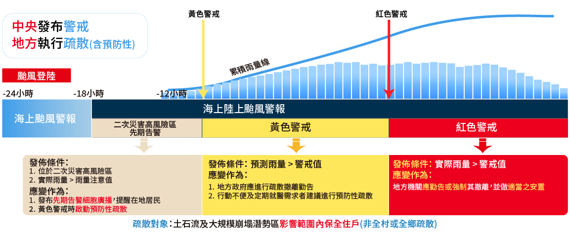
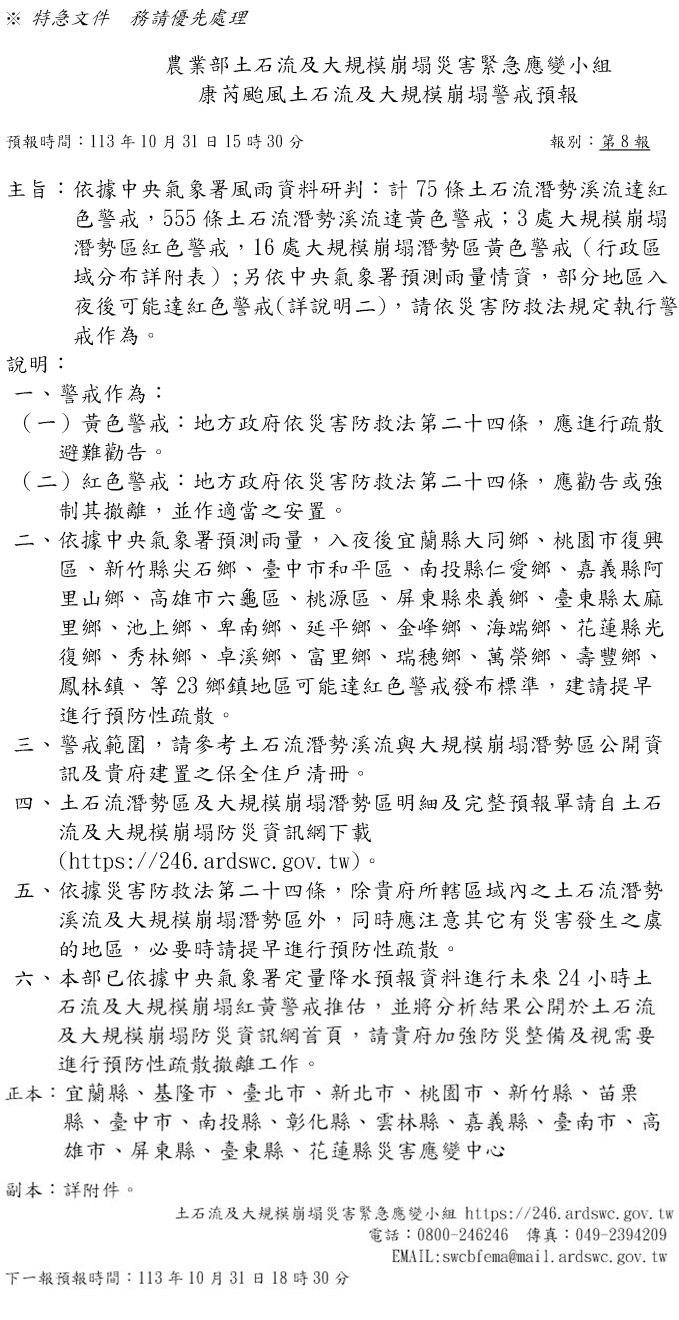
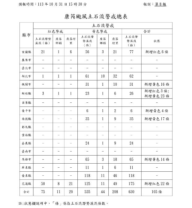
Based on weather forecasts and rainfall data provided by the Central Weather Administration of the Ministry of Transportation and Communications, the Ministry of Agriculture utilizes the debris flow and massive landslide alert criteria established by the Ministry of Agriculture to assess the likelihood of debris flow and massive landslide disasters, and issues corresponding alerts (Red or Yellow Alert). Local governments may, based on actual local conditions, issue evacuation warnings and relocate residents from hazardous areas when necessary, aiming to achieve the goal of near-zero disaster casualties.
Scheduled Issuance Mechanism and Forecast Sheet Format
Alert Forecast
The release time of the 1st alert depends on actual conditions
Scheduled Issuance
Issued in conjunction with quantitative precipitation forecasts from the Central Weather Administration, scheduled issuance **6 times** a day
Unscheduled Issuance
Alerts are issued unscheduled in response to special wind and rain conditions
00:30
06:30
12:30
Add a reminder for areas that may reach Red Alert status after nightfall
15:30
Add a reminder for areas that may reach Red Alert status after nightfall
18:30
Add a reminder for areas that may reach Red Alert status after nightfall
21:30
Illustration: Alert forecast sheet format diagram.
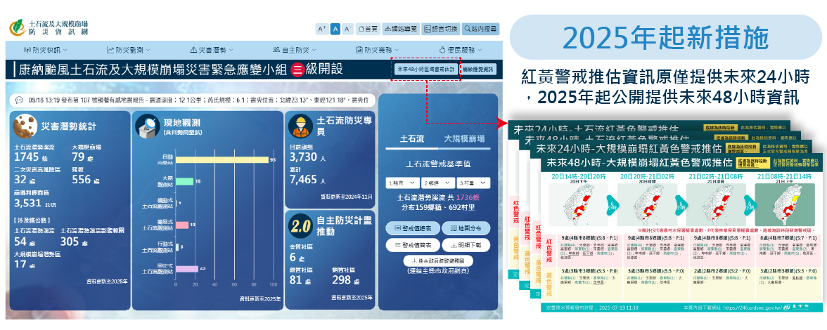
Number of Debris Flow and Massive Landslide Alerts
Future 48-Hour Red and Yellow Alert Estimation Information
During the period of emergency response activation, the Ministry of Agriculture, based on the quantitative precipitation forecast from the Central Weather Administration, also provides a future 24-hour Red and Yellow Alert estimation on the homepage of the Debris Flow and Massive Landslide Disaster Prevention Information Website, strengthening the ability of local governments to plan evacuation operations in advance.
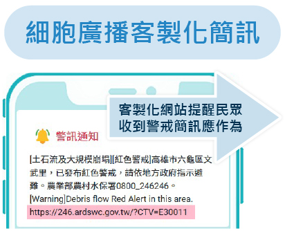
CBSMessage Content and Customized Page
Led by the National Communications Commission (NCC), **Planned by the National Science and Technology Center for Disaster Reduction (NCDR)**,
this service utilizes the Cell Broadcast Service (CBS) technology of mobile communication systems through telecommunication operators' mobile broadband systems
to **broadcast alert messages to a large number of mobile phones within a specific area in a short time. When the phone receives the message, it triggers a special sound and vibration**,
allowing the public to grasp disaster information early.
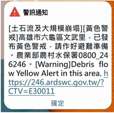
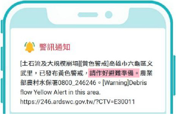
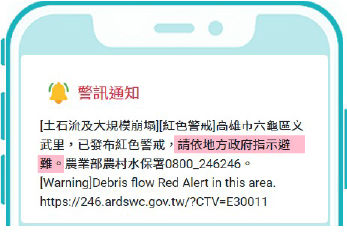
Illustration: Issued by the Ministry of Agriculture's Agency of Rural Development & Soil and Water Conservation
Illustration: Issued by local government
Issuance at Different Stages
(Issue Yellow, Elevate to Red)
Re-issued only when the alert status changes to reduce repeated message reception by the public.
Establish Alert Information Page
Provide detailed and diverse services; cell broadcast text can include a customized page URL.
Customized Page URL Public Location-Based Access, Exclusive Response Information
Provide Five Core Information Items:
Where is the Alert Area
What Should I Do
Current Rainfall Conditions
Recommended Disaster Preparedness Items
Evacuation Shelters and Phone Numbers
The original default cell broadcast messages for Red and Yellow Alerts were both "Please stay highly vigilant," lacking a clear distinction. This has been adjusted to:
Yellow Alert is 「Please prepare for evacuation」
Red Alert is 「Please evacuate according to local government instructions」
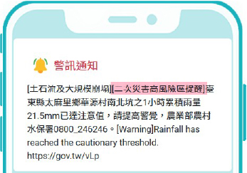
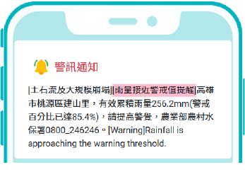
Added: During the period when the Agency of Rural Development & Soil and Water Conservation's Emergency Response Team is NOT activatedRainfall approaching alert value reminder
High Secondary Disaster Risk Area Early Warning Cell Broadcast Message
Rainfall Approaching Alert Value Reminder
Yellow Alert
Red Alert
Each cell broadcast message includes built-in Red and Yellow Alert information and customized webpage links for each village/neighborhood, **providing the public with five core information items**: **Where is the alert area, what should I do, current rainfall conditions, recommended disaster preparedness items, and evacuation shelters and phone numbers.**
Yellow Alert
Rainfall is already approaching the debris flow and massive landslide alert values, and according to the Central Weather Administration's precipitation forecast, there is still a chance of continuous heavy rain in the future. It is recommended to start preparing your personal belongings and prepare for evacuation!
Red Alert
Rainfall is significant and has reached the debris flow and massive landslide alert values. It is recommended to immediately take necessary evacuation measures and proceed to a safe shelter.
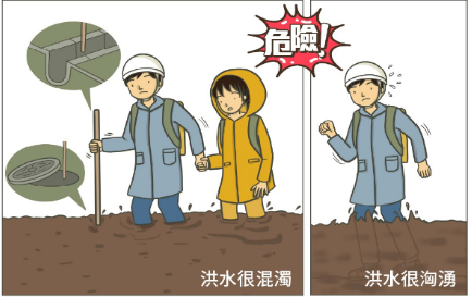
Pay Attention to Evacuation Routes During Floods
When evacuating and encountering flooded roads, use a long stick to check the safety underfoot to avoid falling into ditches or potholes. If the water depth exceeds 50cm, even adults may lose their footing and be swept away by the flood. You should move away quickly.