Investigation and Assessment of Large-scale Landslide Potential Zones
Investigation of Large-scale Landslide Potential Zones
The occurrence of large-scale landslides is associated with specific topography and geology. Therefore, by analyzing the terrain and geological surveys of slopes, potential areas can be inferred. Except for special geological or topographical conditions (such as dip slopes), the sliding surface of a large-scale landslide does not form abruptly; it evolves over a long period of time. During the development of the sliding surface, micro-topographical signs of collapse are left on the ground surface. Thus, with good tools (such as high-precision digital elevation models) and detailed field verification, locations with landslide potential can be identified.
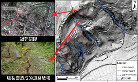
Due to the dense forests in Taiwan's mountainous areas, it is not easy to directly interpret cracks and surface features caused by landslides. Therefore, high-precision digital elevation data can be used to generate hillshade maps and slope maps to understand the surface features beneath the vegetation, and observe whether they have crown, depression, and bulge zones (Figure 2-1)
Illustration: Figure 2-1 Surface Features of Large-scale Landslide Potential Zone
Historical Investigation of Large-scale Landslides
Since Typhoon Morakot in 2009, to prevent the recurrence of large-scale landslide disasters like the one in Xiaolin Village, relevant agencies conducted interpretations of micro-topographical features in potential large-scale landslide areas, identifying a total of 9,948 areas with the potential for large-scale landslides. Considering the scale of the disaster, the Rural Development & Soil and Water Conservation Agency of the Ministry of Agriculture further focused on 315 medium-to-high-risk areas with safeguard households as the scope of project implementation. In addition to analyzing the frequency and security level of the aforementioned areas, Interferometric Synthetic Aperture Radar (InSAR) analysis was used to assess their activity level, thereby selecting 103 higher-risk large-scale landslide potential zones as performance indicators for the second phase of the Large-scale Landslide Disaster Prevention and Mitigation Plan under Climate Change.
Assessment of Large-scale Landslide Risk Potential Level
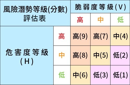
The assessment method for the potential of large-scale landslide potential zones is a comprehensive evaluation based on two assessment factors: "Hazard (H)" and "Vulnerability (V)". Specifically, "Hazard (H)" uses the "Grading of Hazard Assessment Factors for Large-scale Landslide Potential Zones," and "Vulnerability (V)" uses the "Grading Table of Vulnerability Assessment Factors for Large-scale Landslide Potential Zones." After scoring and grading separately, a risk level (score) assessment table is then used to comprehensively evaluate the risk potential level.
The large-scale landslide hazard assessment process mainly includes data collection and selection, factor processing and grading (such as slope, distance to geological structural lines, distance to river channels, dip slope terrain characteristics, and activity level, etc.), factor weight scoring, and hazard grading. The grading results are classified into high, medium, and low.
Vulnerability Scoring and Grading
In terms of vulnerability assessment, all important safeguard targets within the potential impact range of a large-scale landslide, such as households, transportation (including railways, highways, and bridges), and critical public facilities, must be considered. After summing up the vulnerability scores of the large-scale landslide potential zone, the grading results are classified into high, medium, and low.
Delimitation of Large-scale Landslide Impact Area
The main purpose of the delimitation of the large-scale landslide potential zone impact area is to provide the operating procedures and methods for various levels of government and the public to carry out disaster prevention and mitigation related to large-scale landslides. Therefore, the most conservative principle is adopted for the investigation, simulation, and assessment of the delimited area. The operating procedures and methods include the following four tasks for the large-scale landslide potential zone: "Application for Addition and Adjustment," "Field Investigation," "Potential Assessment," and "Data Review."
Addition and Adjustment Operations
Addition Operations
Adjustment Operations
Field Investigation Operations
Preparation of Basic Data
Detailed Field Investigation Operations
Map Data Editing
Potential Assessment Operations
Hazard Assessment
Vulnerability Assessment
Potential Level Assessment
Data Review Operations
Holding Information Sessions
Holding Review Meetings
Flowchart for Delimitation of Large-scale Landslide Potential Zone Impact Area
The preliminary delimitation of the impact area is conducted using the scale and topographic data of the large-scale landslide potential zone, involving two tasks: "Identification of Possible Disaster Types" and "Preliminary Delimitation of the Impact Area." "Identification of Possible Disaster Types": Based on the scale and location of the large-scale landslide potential zone, the possible disaster types are classified and identified, which can be divided into (1) Gravity Deposition Type; (2) Debris Flow Type; and (3) Landslide Dam Type. "Preliminary Delimitation of the Impact Area": Based on the analysis results of possible disaster types, corresponding calculation formulas are used to calculate the reference dimensions of the impact area, which are then fine-tuned according to the terrain.
1. Gravity Deposition Type Delimitation Method
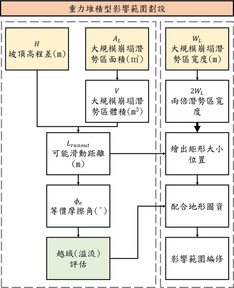
For the delimitation of the impact area of the Gravity Deposition Type, the delimitation should be carried out by referencing the potential sliding distance Lrunout and delimiting the potential deposition width WMax. The calculation process is shown in Figure 2-3.
Illustration: Figure 2-3 Flowchart for Delimitation of Gravity Deposition Type Impact Area
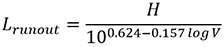
Potential Sliding Distance Lrunout:
The potential sliding distance of a landslide can be determined through the equivalent friction coefficient.
Where H is the elevation difference of the slope crown (m), V is the volume of the large-scale landslide potential zone (m3), and (AL) is the area of the large-scale landslide potential zone (m2),
Potential Deposition Width WMax:
Determined based on the landslide width WL and the deposition width WMax.
WMax = 1.5 ~ 2W L. In response to disaster prevention needs, it is recommended to delimit the potential deposition width as two times the landslide width, WMax = 2W L
2. Debris Flow Type Delimitation Method
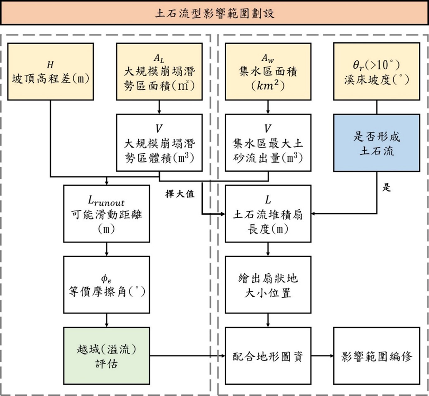
The delimitation of the debris flow type impact area refers to the current method used by the Rural Development & Soil and Water Conservation Agency of the Ministry of Agriculture for delimiting the impact area of potential debris flow streams. The delimitation is mainly based on the location of the valley mouth and/or overflow point and the angle of the alluvial fan. The radius length of the alluvial fan is calculated using the Ikeya formula, but the potential sediment runoff in the formula should consider both the runoff from the catchment area and the potential sediment from the large-scale landslide potential zone. Additionally, the river channel range between the potential zone and the deposition fan needs to be considered (Figure 2-4).
Illustration: Figure 2-4 Flowchart for Delimitation of Debris Flow Type Impact Area
Debris Flow Alluvial Fan Length L: The radius length of the alluvial fan can be calculated using the Ikeya formula. log(L) = 0.42×log(V×tan θd) + 0.935
Where L is the debris flow alluvial fan length
(m)、
V is the sediment runoff volume
(m3)、
θd is the slope of the alluvial fan (°).
The sediment runoff volume can be calculated by taking the larger value from the following methods.
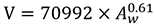
Maximum Sediment Runoff from Catchment Area:
, where AW is the catchment area (km2).
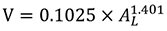
Landslide Earth Volume:
, where AL is the area of the large-scale landslide potential zone m2.
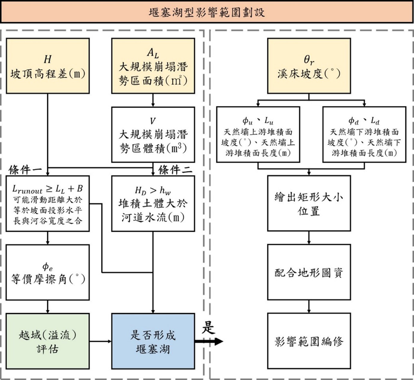
3. Landslide Dam Type Delimitation Method
The delimitation of a landslide dam needs to be carried out under the conditions where a landslide dam is likely to form. A landslide dam can only be determined to have formed when the soil body conditions meet the formation criteria. The deposition range of the natural dam can be assessed based on the dam body's deposition shape (Figure 2-5).
Illustration: Figure 2-5 Flowchart for Delimitation of Landslide Dam Type Impact Area
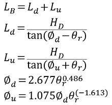
Calculated to determine the natural dam's downstream deposition surface length Ld
and the natural dam's upstream deposition surface length Lu,
The sum of the two is the natural dam deposition length LB, and its calculation formula is as follows:
Where LB is the natural dam deposition length (m),
Ld is the natural dam's downstream deposition surface length (m),
Lu is the natural dam's upstream deposition surface length (m),
HD is the minimum deposition height of the landslide dam's natural dam (m),
∅d is the natural dam's downstream deposition surface slope (°),
∅u is the natural dam's upstream deposition surface slope (°),
θr is the river valley slope (°).


 , where AW is the catchment area (km2).
 , where AL is the area of the large-scale landslide potential zone m2 .
 Where H is the elevation difference of the slope crown