Top Navigation Bar

@*土石流及大規模崩塌防災資訊網logo圖片*@ Debris Flow and Large-Scale Landslide Disaster Prevention Information Network logo image @*土石流及大規模崩塌防災資訊網名稱圖片*@ Debris Flow and Large-Scale Landslide Disaster Prevention Information Network name image
Debris Flow and Large-Scale Landslide Disaster Prevention Information Network

應變開設專區

0814豪雨土石流及大規模崩塌災害緊急應變小組 級開設 未來48小時紅黃警戒推估

警戒統計資訊

紅色警戒

  • 0
    土石流潛勢溪流
  • 0
    縣市
  • 0
    鄉鎮
  • 0
    村里
  • 0
    大規模崩塌潛勢區
  • 0
    縣市
  • 0
    鄉鎮
  • 0
    村里

黃色警戒

  • 0
    土石流潛勢溪流
  • 0
    縣市
  • 0
    鄉鎮
  • 0
    村里
  • 0
    大規模崩塌潛勢區
  • 0
    縣市
  • 0
    鄉鎮
  • 0
    村里

警戒地圖與縣市列表

桃園市
土石流警戒 0 0
大規模崩塌警戒 0 0
目前無發布任何警戒
新竹縣
土石流警戒 0 0
大規模崩塌警戒 0 0
目前無發布任何警戒
苗栗市
土石流警戒 0 0
大規模崩塌警戒 0 0
目前無發布任何警戒
臺中市
土石流警戒 0 0
大規模崩塌警戒 0 0
目前無發布任何警戒
彰化縣
土石流警戒 0 0
大規模崩塌警戒 0 0
目前無發布任何警戒
雲林縣
土石流警戒 0 0
大規模崩塌警戒 0 0
目前無發布任何警戒
嘉義縣
土石流警戒 0 0
大規模崩塌警戒 0 0
目前無發布任何警戒
臺南市
土石流警戒 0 0
大規模崩塌警戒 0 0
目前無發布任何警戒
新北市
土石流警戒 0 0
大規模崩塌警戒 0 0
目前無發布任何警戒
高雄市
土石流警戒 0 0
大規模崩塌警戒 0 0
目前無發布任何警戒
臺北市
土石流警戒 0 0
大規模崩塌警戒 0 0
目前無發布任何警戒
基隆市
土石流警戒 0 0
大規模崩塌警戒 0 0
目前無發布任何警戒
宜蘭縣
土石流警戒 0 0
大規模崩塌警戒 0 0
目前無發布任何警戒
南投縣
土石流警戒 0 0
大規模崩塌警戒 0 0
目前無發布任何警戒
花蓮縣
土石流警戒 0 0
大規模崩塌警戒 0 0
目前無發布任何警戒
臺東縣
土石流警戒 0 0
大規模崩塌警戒 0 0
目前無發布任何警戒
屏東縣
土石流警戒 0 0
大規模崩塌警戒 0 0
目前無發布任何警戒

Hazard Potential

·

What is a Debris Flow

Common Debris Flow Warning Methods

『Debris flow』 warning models are primarily divided into two types: **contact-based (event-triggered)** and **non-contact-based (pre-event)**. 『Contact-based』 systems detect the flow in real-time after a 『debris flow』 has occurred, typically using wire ropes, geophones, or other sensors to immediately alert residents for evacuation. Their advantage is high accuracy, but they are limited by short warning times, difficult equipment maintenance, and high construction costs. 『Non-contact-based』 systems use rainfall as the primary threshold for 『debris flow』 occurrence; residents are notified to evacuate when rainfall exceeds a set threshold. These systems offer the advantages of earlier warning times, easier equipment maintenance, and simple data transmission, but their accuracy is generally lower.

Contact-Based (Event-Triggered)
  • Detection Method: Wire ropes, geophones, and other means to detect 『debris flow』
  • Advantages: High accuracy
  • Disadvantages: Insufficient warning time, difficult equipment maintenance, high construction costs
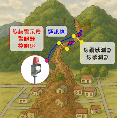
Non-Contact-Based (Pre-Event)
  • Detection Method: Uses rainfall as the 『debris flow』 warning threshold
  • Advantages: Longer warning time, easier equipment maintenance and data transmission
  • Disadvantages: Lower accuracy
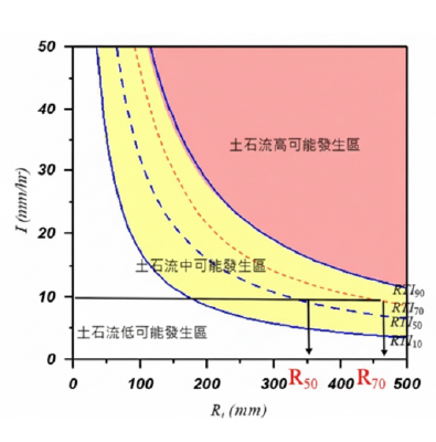
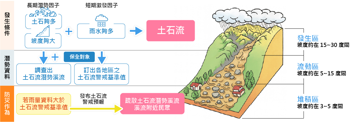
Debris Flow Occurrence Conditions and Warning Framework

The occurrence of a 『debris flow』 is primarily influenced by a combination of long-term potential factors and short-term triggering factors. Long-term potential factors include steep slopes and an ample supply of soil and sediment, while the short-term triggering factor is rainfall reaching the warning criteria. To effectively prevent 『debris flow』 disasters, it is essential to first identify the local 『debris flow potential area』 streams and the populations at risk, and then to establish 『debris flow』 warning thresholds. When rainfall data exceeds the established warning threshold, the system immediately issues a warning forecast, notifying residents near the potential streams for early evacuation, thereby reducing the risk of disaster. The overall framework is divided into three main components: occurrence conditions, potential data, and disaster prevention actions.

International Practices for Debris Flow Warning

The 『debris flow』 and related slope disaster warning practices in Japan and the United States.

Japan's RBFN System

Japan launched a nationwide warning system for 『debris flow』 and slope disasters in 2005. The system primarily utilizes runoff indices, such as 60-minute cumulative rainfall and a soil moisture index, to set the criteria for 『debris flow』 and slope disaster occurrences. Due to the lack of precise records for disaster occurrences in many areas, the system employs the Radial Basis Function Network (RBFN) method to establish a warning model based on the correlation between historical rainfall data and disaster occurrences. Since March 2007, relevant warning information has been disseminated via media such as television, radio, and the internet during heavy rainfall conditions to enhance public disaster awareness and response capabilities.

USGS Warning System

The U.S. Geological Survey (USGS), in partnership with the National Oceanic and Atmospheric Administration (NOAA), established a demonstration flash flood and 『debris flow』 warning system in Southern California. This system predicts the likelihood of a 『debris flow』 by comparing radar-estimated rainfall data with established rainfall intensity-duration thresholds. When the system determines there is a risk of a 『debris flow』, a warning is issued through the National Weather Service's (NWS) Advanced Weather Interactive Processing System (AWIPS), and relevant emergency response units are notified for appropriate action.

Reference Sources (Delete before official launch)

1. Public Presentation Slides P16, P17
2. International Practices (Japan RBFN, USA)

頁面頂端

分享與工具列